
On Tuesday 26 January, ECMWF upgraded the horizontal resolutions of its deterministic forecast and data assimilation systems and the Ensemble Prediction System (EPS), including the weekly extension to 32 days.
A new cycle of the IFS model has been introduced to implement the higher resolution upgrade. This cycle is labelled 36r1. The resolution of the deterministic model is increased from T799 (25 km grid) to T1279 (16 km); the EPS resolution changes from T399 (50 km) to T639 (32 km) for the first 10 days of the forecast and from T255 (80 km) to T319 (65 km) for day 10 onwards. The higher resolution results in a better representation of features such as tropical storms, fronts, heavy rainfall and land/sea transitions.The impact of the new cycle on the performance of the deterministic forecast system has been tested on more than 500 cases. Objective verification shows significant improvements for 1000 and 500 hPa height, 850 hPa temperature and wind at most levels. The location and intensity of synoptic features are improved in many cases.

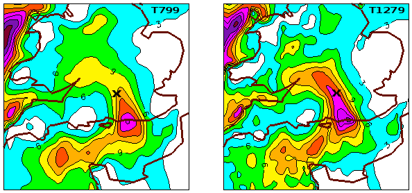
The new high-resolution model (right) captured the exceptional snowfall event that affected southern England on 5/6 January this year very well. Panels show precipitation totals (mm liquid water equivalent) forecast by the old (T799) and the new (T1279) model versions in the period 00 UTC 5 January 2010 (T+0h) to 09 UTC 6 January (T+33h). The cross marks ECMWF, where 27 cm of fresh snow was measured. This melted down to about 20 mm of rainfall equivalent, which is much closer to the T1279 forecast (~18 mm).
The higher resolution wind fields are better at representing features such as tropical storms, fronts and land/sea transitions which translates into better wave forecasts. Tropical cyclone track and intensity forecasts are generally improved in the higher-resolution system, based on the relatively small sample available.
The overall benefit of the T639 EPS is reflected in the results for the probability scores which are consistently improved for 500 hPa height anomalies and 850 hPa temperature anomalies. EPS spread is in general unchanged. The EPS ensemble-mean errors are consistently lower, resulting in some overestimation of spread in terms of 500 hPa height and a better tuned spread in terms of 850 hPa temperature.
