

An upgrade of ECMWF’s Integrated Forecasting System (IFS) to Cycle 49r1 implemented on 12 November has substantially improved near-surface wind and temperature predictions, particularly for the winter months in the northern hemisphere.
IFS Cycle 49r1 includes the data assimilation of two-metre temperature observations to help establish the initial conditions of forecasts. It also changes the Ensemble of Data Assimilations, which provides estimates of the uncertainty in the initial conditions.
The upgrade activates a new scheme to determine model uncertainty for ensemble forecasts. These forecasts, which are produced as a standard by ECMWF, have slightly varying initial conditions and approximations in the model. They enable us to draw conclusions on the probability that particular outcomes will materialise.
There are also improvements to the use of observations to help establish the initial conditions of forecasts, and changes in the ocean wind wave model component have been implemented.
Near-surface wind and temperature predictions
Data assimilation is achieved by combining a previous short-term forecast with observations. In IFS Cycle 49r1, two-metre temperature is for the first time assimilated in the atmospheric component of the data assimilation system, 4D-Var. The change has proved beneficial after extensive testing and tuning.
Changes towards a more realistic physical representation of processes in the model also led to improved temperature forecasts.
The result of all the changes made in IFS Cycle 49r1 is improved two-metre temperature forecasts, especially in northern hemisphere winter. More details are available in a winter 2023/24 Newsletter article.
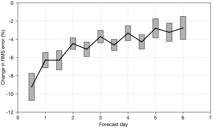
The impact of IFS Cycle 49r1 on two-metre temperature forecasts verified against SYNOP observations (percentage change in root-mean-square error) for December 2021 to February 2022, 20°–90°N. The grey rectangles show 95% confidence intervals.
Forecasts of ten-metre wind speed are improved throughout the year. The largest impacts are for the winter months of the northern hemisphere.
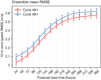
The chart shows the root-mean-square error (RMSE) of the ensemble mean for ten-metre wind speeds from Cycle 48r1 (blue) and Cycle 49r1 (red), verified against observations and averaged over the northern hemisphere. All scores are calculated using 50 perturbed members from 75 forecasts initialised daily between 1 December 2022 and 13 February 2023. The vertical bars represent 95% confidence intervals.
New scheme for model uncertainty
The new model uncertainty scheme is called Stochastically Perturbed Parametrizations (SPP), and it replaces the previous Stochastically Perturbed Parametrization Tendencies (SPPT) scheme.
SPP represents model uncertainties closer to the sources of the errors than SPPT does. An example of the improvements it brings is provided by the illustration below. More details are available in an autumn 2024 Newsletter article.
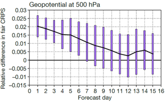
Relative differences in fair CRPS (continuous ranked probability score) of an ensemble using SPP and an ensemble using SPPT in the northern extratropics, for geopotential at 500 hPa verified against analyses. Positive values indicate higher forecast skill for the ensemble using SPP. Shown are combined scores for northern winter 2021/2022 and summer 2022 (282 start dates). The experiments use a resolution of 9 km (TCo1279) and eight perturbed members initialised from operational initial conditions. The vertical bars show 95% confidence intervals for the score differences.
The use of observations
An important step towards a fully integrated Earth system assimilation system in Cycle 49r1 is the activation of microwave imaging radiances over sea-ice surfaces within the atmospheric 4D-Var component.
The addition of data from Advanced Microwave Scanning Radiometer 2 (AMSR2) and the Global Precipitation Measurement Microwave Imager (GMI) in sea ice and neighbouring areas improves forecast scores in the vicinity of Antarctica by around 0.5% out to day 4. More details on this change can be found in an autumn 2023 Newsletter article.
Numerous other observation-related contributions to Cycle 49r1 were made.
Ocean wind wave model
Cycle 49r1 includes several scientific and technical changes to the ocean wind wave model, including a revision of the horizontal grid to match the atmosphere resolution in all forecasts. This corresponds to a reduction of the wave model grid spacing to about 9 km (TCo1279) in medium-range forecasts and about 36 km (TCo319) in sub-seasonal forecasts.
There are positive effects on wave height forecasts compared to ECMWF’s analysis and observations, and the ocean changes lead to a clear improvement in atmospheric temperature scores.
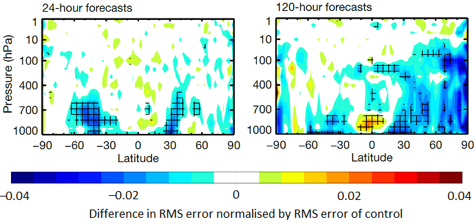
Normalised change in temperature forecast root-mean-square (RMS) error, measured against own analysis, showing the impact of all wave-model-related changes, for combined winter and summer seasons. Cross-hatching indicates statistical significance at a confidence level of 95%. Blue areas indicate a reduction in RMS error and hence a beneficial impact.
More details about ocean-wave-related changes in Cycle 49r1 can be found in a spring 2024 Newsletter article.
More information
A detailed summary of all changes in IFS Cycle 49r1 and their effects on forecasts can be found in an autumn 2024 Newsletter article.
