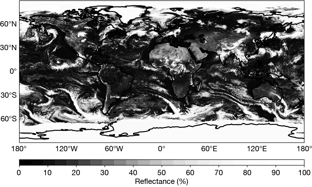
Since 2016, global simulated infrared brightness temperatures have provided an exciting and unique view of the atmosphere predicted by ECMWF’s high-resolution Integrated Forecasting System (IFS), up to ten days into the future. More recently, the generation of simulated images from ECMWF forecasts has been further extended to visible reflectances. Reflectance, expressed as a percentage, is the ratio between outgoing and incoming solar shortwave radiation. The new development will not only provide valuable information about the larger-scale dynamics but will also enable the study of meteorological features that are usually not well detected at infrared frequencies, such as low‑level clouds and fog.
The move to visible reflectances follows recent progress in the NWPSAF (Numerical Weather Prediction Satellite Application Facilities) in radiative transfer modelling at visible wavelengths. It also comes after the integration of an RTTOV-13.0/MFASIS (Method for FAst Satellite Image Synthesis) look-up-table-based observation operator in Cycle 48r1 of ECMWF’s IFS. Reflectances that would be seen in a visible channel (for example at 640 nm) can now be computed during the model run at every grid point.

Capturing clouds and surface conditions
The example image shown assumes a nadir view at every model grid point, free from real-life satellite geometry distortions at high latitudes. It enables a unique perspective, to see the entire globe in perpetual daylight at various forecast lead times. Under the assumption that both the sun and satellite are overhead everywhere, the effect of sun glint over sea and lakes is not considered.
A key advantage of simulating reflectance is the ability to capture Earth's clouds at multiple scales and heights throughout the troposphere, as well as variations in surface conditions associated with soil properties, vegetation, and snow cover. The figure shows multiscale meteorological patterns: cyclones over the North Atlantic; a synoptic-scale frontal system stretching over Central Europe; bands of deep convective clouds spanning around the equatorial Pacific and Atlantic, indicative of the Intertropical Convergence Zone (ITCZ). In addition, the bright Saharan desert contrasts with the darker tropical rainforests of Central Africa, and sea ice around Antarctica and in the Arctic is easily distinguishable from the darker surrounding oceans.
The simulation of top-of-the-atmosphere visible reflectances will soon be an integral part of the operational IFS. It will be available within the standard delivery times of all other ECMWF data and products. This product, available in three-hourly steps up to day two, six-hourly steps up to day five, and twelve-hourly steps up to day ten, will complement the infrared images already available in ECMWF’s catalogue and will be available to the Centre’s Member and Co‑operating States.
Extreme weather events
The new product will play a crucial role in improving the visualisation of forecasts of high-impact extreme weather events through the complementarity of infrared and visible frequencies. It also provides enhanced capabilities to capture weather patterns over a wide range of spatial and temporal scales.
In addition, the new product will be available at km‑scale in the context of the EU's Destination Earth (DestinE) initiative, where simulated visible reflectances will support the evaluation of extreme weather forecasts. While shorter time intervals uncover the evolution of squall lines or storm tracks in greater detail at the km-scale, Rossby wave patterns in the mid-latitudes or hurricanes in the tropics appear as distinct features in the simulated visible imagery and could help forecasters to better assess model performance.
This work is also relevant to developments towards the assimilation of solar reflectances in ECMWF’s 4‑dimensional variational data assimilation system (4D‑Var).
