As part of the European Commission’s Destination Earth (DestinE) initiative, ECMWF is developing a digital twin focused on weather-induced extreme events. This digital twin (Extremes DT) includes a global component, created using ECMWF’s Integrated Forecasting System (IFS) at 4.4 km resolution, and a regional component over Europe, at 500 to 700 m resolution, developed by a consortium led by Météo-France involving several national meteorological services.
ECMWF has been running the global Extremes DT daily for over a year. To assess its performance, ECMWF conducted a preliminary evaluation of five-day 4.4 km forecasts initialised daily from 1 September 2023 to 31 August 2024 from the ECMWF operational analysis. This evaluation provided valuable insights into the added value of km-scale simulations, particularly regarding the representation of extreme weather events, and for future model improvements.
The evaluation shows that the global Extremes DT improves the prediction of certain extreme phenomena compared to ECMWF’s 9 km operational forecasts. For example, the 4.4 km resolution enhances the intensity prediction of tropical cyclones (TC) in general, but particularly for some rapidly intensifying TCs. It also improves the representation of extreme precipitation in mountainous areas, thanks to better orographic representation.
Enhanced precipitation forecasts over complex orography
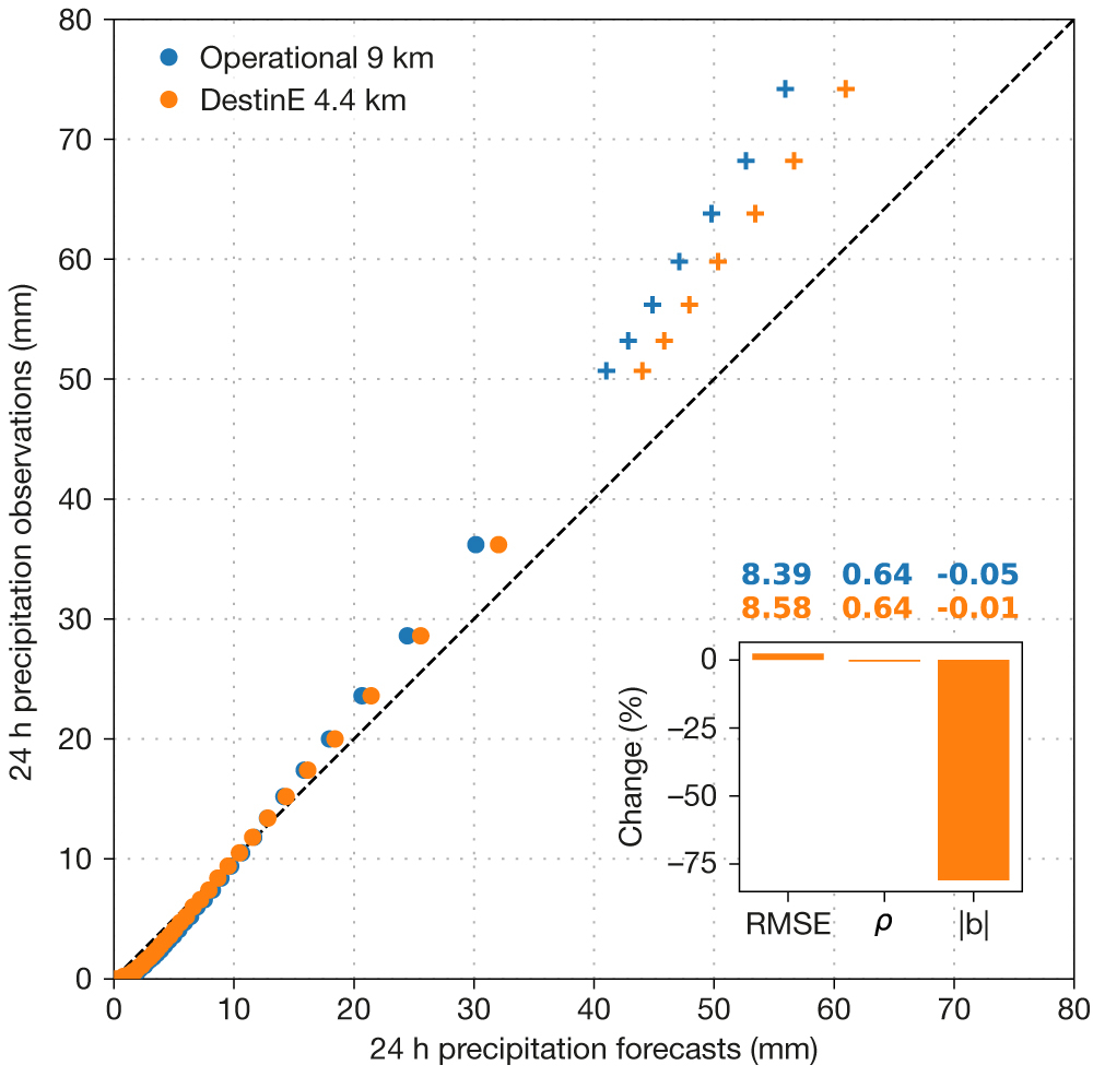
In terms of extreme precipitation, this one year of data has demonstrated that the 4.4 km resolution of the Extremes DT brings an improvement of the global forecast performance in complex orographic areas, compared to the 9 km resolution. This is noticeable across most percentiles of the precipitation distribution, as shown in the first figure. Both the overestimation of small 24 h precipitation values and the underestimation of very large precipitation values observed in the 9 km forecast are reduced, which leads to a smaller absolute bias.

Increasing the resolution from 9 km to 4.4 km also significantly reduces the occurrence of false alarms for extreme convective precipitation over small but complex orographic islands (i.e. Tenerife). These false alarms are due to an overestimation of the moisture convergence closure of the convective parametrization when small mountain ranges with steep slopes are under-resolved. Higher resolutions mitigate this issue.
Higher resolution enables more accurate tropical cyclone intensity prediction
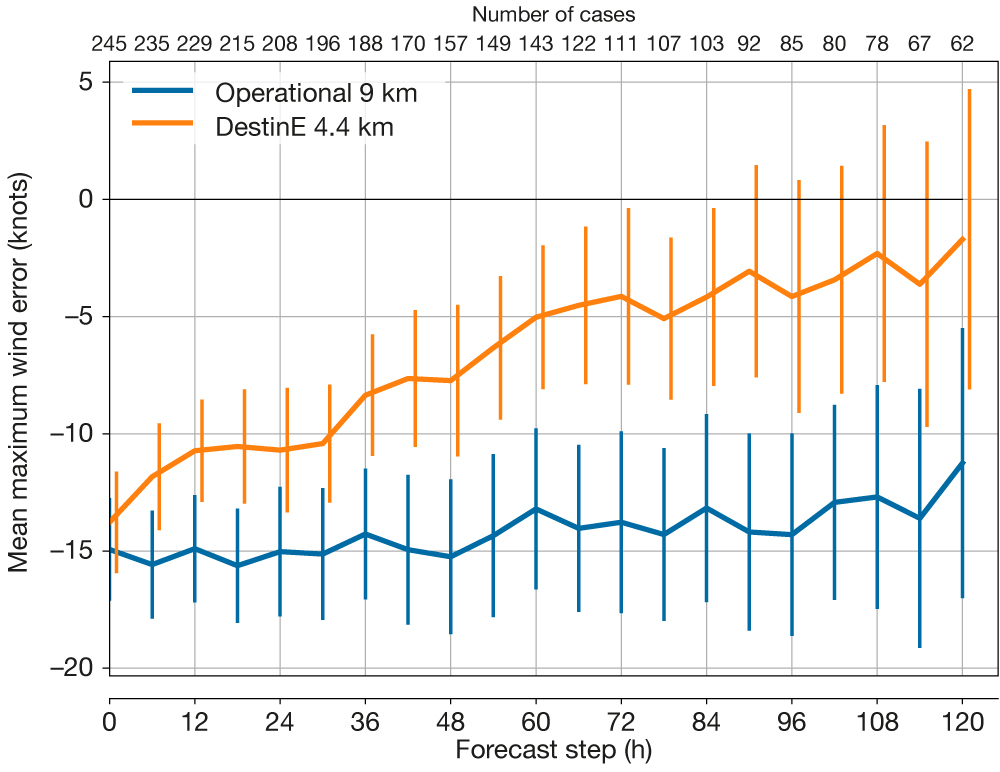
The evaluation of all TCs occurring globally in the one-year verification period clearly demonstrates a great benefit of running the IFS at higher resolution for TC intensity prediction. While the TCs are always 12–15 knots weaker on average than observed in 9 km forecasts up to 120 h ahead, the initially equally large bias in the 4.4 km forecasts steadily reduces until it almost vanishes on day five (see the second figure). This confirms our experience from monitoring forecast performance for individual TCs during that one year: DestinE forecasts were usually better at predicting both TC intensification and peak intensity.

The fact that the bias at initialisation time remains almost unchanged highlights that the resolution increase in the forecast model should ideally be accompanied by a higher-resolution 4D‑Var analysis. Initial tests in this direction are promising as they show, for example, that the explosive rapid intensification of TC Otis (2023) could have been accurately predicted if the DestinE forecast had been initialised from a higher-resolution 4D‑Var with a 12‑hour window, together with a reduced dependence on the convection scheme.
Addressing remaining challenges
Despite promising results from this one‑year evaluation of Extremes DT daily forecasts, some challenges remain. An example is the overestimation of very cold 2 m temperatures globally in very stable boundary layers. This is likely caused by increased vertical wind shear due to better resolved orography. However, this aspect has significantly improved in DestinE 4.4 km simulations carried out with the new IFS Cycle 49r1, which is to be implemented in November 2024. This is thanks to the inclusion of 2 m temperature in data assimilation and enhanced 2 m diagnostics. Some issues with convective precipitation still persist, such as the failure to propagate marine convective precipitation further inland. Tuning the cloud base convective mass flux in the convective parametrization has shown potential to help, but as it causes some forecast degradation in the tropics, it still requires further investigation. In view of the enhancements that high-resolution 4D‑Var has brought in the case of TC Otis, as mentioned above, we will undertake a more comprehensive investigation into its added value for the representation of extreme weather events. These aspects will be key points of investigation for Phase II of DestinE (2024–2026).
