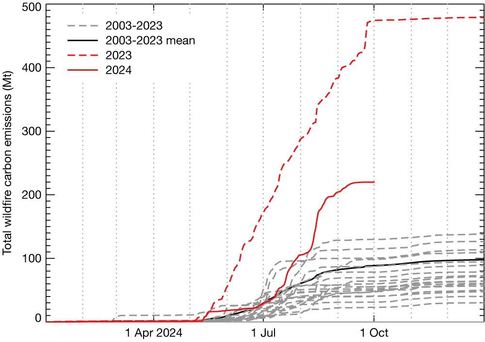
During the summer of 2024, a large number of wildfires burned across Canada, primarily the western part of the country. According to estimated biomass burning emissions from the Copernicus Atmosphere Monitoring Service (CAMS), implemented by ECMWF for the EU, they resulted in the second-highest annual total emissions since the start of systematic monitoring in 2003. They were only surpassed by the historic Canadian wildfires which burned from May to September 2023 (see the first figure).

Location of fires
The first significant fires of 2024 occurred in May in western Canada. The British Colombia Wildfire Service attributed them to the surface reignition of holdover fires which had been smouldering underground through the winter. Most of the fires were relatively localised to the northeastern corner of British Columbia but resulted in the evacuation of thousands of people. The fires continued in this area through June. The fire count increased significantly through July as large wildfires developed across a wide region of boreal North America, covering Alaska and Canada’s western territories and provinces. The Northwest Territories, as in 2023, contributed the highest number of fires of any region of Canada through August. Further east during August, large fires also developed across Saskatchewan, Manitoba and Ontario.
Monitoring of emissions
As part of CAMS, the Global Fire Assimilation System (GFAS) provides near-real-time monitoring of daily global wildfire locations and emissions. GFAS currently merges fire radiative power observations from the two Moderate-resolution Imaging Spectroradiometer (MODIS) instruments on the NASA Terra and Aqua Earth Observation System satellites. Emissions of a variety of smoke constituents, including carbon monoxide (CO), carbon dioxide (CO2), methane (CH4), black carbon and organic carbon aerosols, nitrogen oxides (NOx), and non-methane hydrocarbons (NMHCs), are estimated in GFAS. They are subsequently used as lower boundary conditions for the operational 5‑day forecasts and analyses of global and regional atmospheric composition produced by CAMS. The GFASv1.2 dataset provides a daily time series that starts in 2003 at a spatial resolution of 0.1 degrees, allowing us to compare current emissions with those in previous available years.
Routine analysis of the GFAS data and CAMS forecasts hinted throughout the summer that the 2024 fire emissions were going to be at an extreme level for the second year in a row. Overall, the total emissions for Canada were established in early August as the second-highest annual total of the past 22 years (see the first figure). However, at the territory/province level different patterns emerged. Twenty-two-year records in monthly total emissions were set for British Columbia (May), Alberta (July), the Northwest Territories (August), Saskatchewan (August), Manitoba (May and August) and Ontario (August). The highest August monthly total emissions were also recorded for Canada.
Effects on air quality and temperature
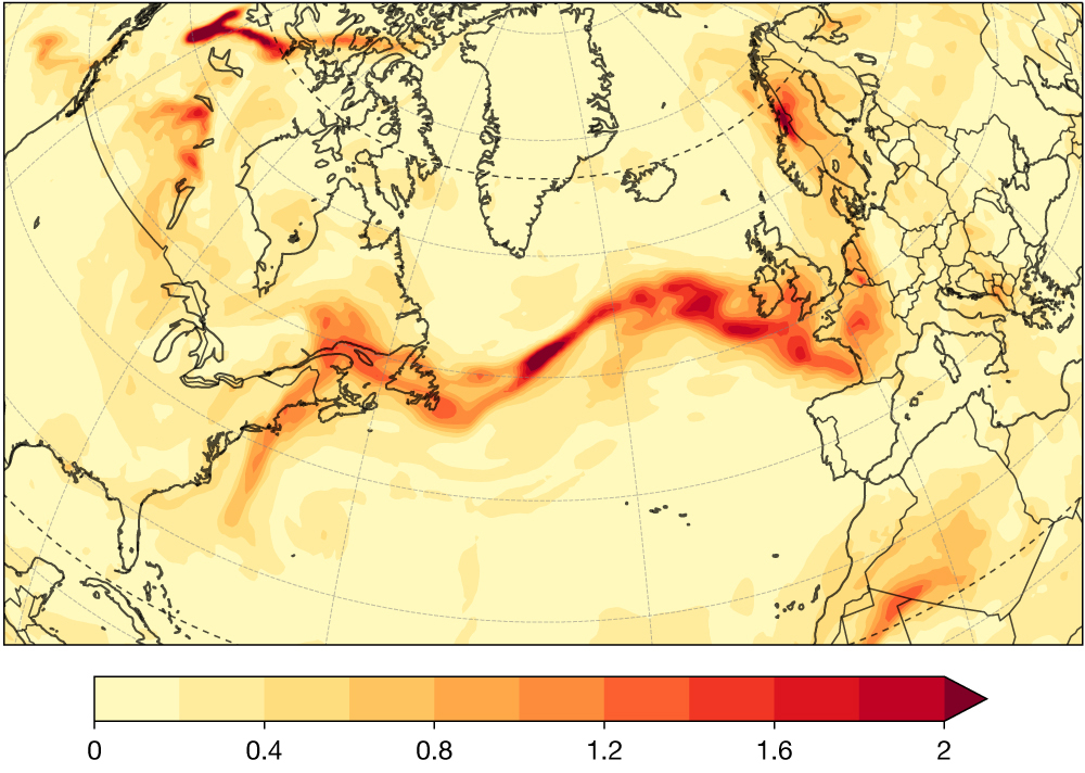
The scale of the 2024 wildfires resulted in severely degraded air quality across western Canada, which also spread as far as eastern Canada and the USA. One notable atmospheric impact, resulting from the increased fire emissions in the Northwest Territories during August, was an episode of long-range smoke transport across the North Atlantic (see the second figure). This was detectable as enhancements to surface PM2.5 concentrations across parts of western Europe. Analysis of the impacts on numerical weather prediction of this smoke transport, comparing the interactive aerosols in the CAMS operational system with a corresponding control run based on the CAMS IFS configuration, but using climatological aerosols, indicated a reduction of up to 2°C in the daily mean 2 m temperature from France to Scandinavia.

Why we monitor wildfire emissions
Canada fires in 2024 have clearly been record-setting and impacting different scales, from local air quality degradation in downwind regions to long-range effects at both the continental and inter-continental scales. CAMS near-real-time monitoring of wildfire emissions around the world and the impacts on atmospheric composition are essential for evaluating the CAMS forecast performance. It also enables applications of CAMS open data on significant episodes which can lead to degraded air quality in near real-time.
